This page describes what we are cooking for the coming iPhone/iPad speedometer version (1.5.2). This is a beta version that is not available yet via AppStore. Here is a list of "What's new" for the publicly available version: http://blocoware.blogspot.cz/2013/06/iphone-and-ipad-speedometer-version-151.html

Here is a list of options for the upper counter:
Current distance -> TIMER -> Average Speed -> Max. Speed
and for the bottom one:
Trip total distance -> TIMER -> Average Speed -> Max. Speed
Rally computer manual: http://blocoware.blogspot.cz/p/weve-just-released-1.html
Status: In beta testing.

In addition to that option, from version 1.5.2, the map scale (zoom level) and viewing angle is remembered. You can change the zoom level at any moment by either double tap or panning the map. Viewing angle can be changed if you hold two fingers on the map and move them down/up to change the angle. This is all governed by Google, and now what you set is being remembered. When map is locked up north a small hint is provided:

Status: In beta testing.
P.S. And just when we were thinking "this is it" for a map, we got a message from @maddogmacattack saying that it would be great to be able to detach the map from "my location" so one can browse around. True. So this option is added to the beta as well! Here it is:

You are free to choose "Don't follow me" and now you can browse around the map as you wish without being force centered on your location every second. You can use same "hold" to re-enable location/direction following or just use a focus button that appears directly on the map when "follow-me" is disabled:


And pick the facebook option for example:

Here is how our post looks before sending, it is pre-filled from the track name and you can change to whatever you like:

You can also change the album that image will be added to and post visibility between "Only Me", "My Friends" and "Public". Tap on "Post" and it will be published on your facebook timeline.
But facebook is only one from many social options! If you pick "More Sharing Options!":

You'll see the plethora of extra sharing options:

It is disputable if you ever need to assign this image to a contact, but we are leaving it here, who knows...
And how the shared image looks? Just for completeness, here it is:

We hope you'll love to share with friends as we do!
Status: In beta testing.
Status: In beta testing.


Status: In beta testing.
Status: In beta testing.
Status: In beta testing.
Status: In beta testing.
Status: In beta testing.
Status: In beta testing.

Status: In beta testing.

Rally computer
This is not a 100% substitute for a $200 rally computer, but may serve you well in many occasions. The idea is, that instead of the map, you can get some selected counters to be shown with quite bigger fonts. You can switch between counters by double tapping on the counter:Here is a list of options for the upper counter:
Current distance -> TIMER -> Average Speed -> Max. Speed
and for the bottom one:
Trip total distance -> TIMER -> Average Speed -> Max. Speed
Rally computer manual: http://blocoware.blogspot.cz/p/weve-just-released-1.html
Status: In beta testing.
More options for the live map. Lock up north, remember the scale and viewing angle.
Showing the map with part ahead of you on top is our preferred way. Though having map top always pointing to the north is quite common as well and convenient to many map experts. From version 1.5.2, the default is still to orient the map in the direction you are moving, but there is an option added in "Advanced Settings>Map Settings":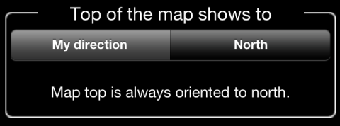
In addition to that option, from version 1.5.2, the map scale (zoom level) and viewing angle is remembered. You can change the zoom level at any moment by either double tap or panning the map. Viewing angle can be changed if you hold two fingers on the map and move them down/up to change the angle. This is all governed by Google, and now what you set is being remembered. When map is locked up north a small hint is provided:

Status: In beta testing.
P.S. And just when we were thinking "this is it" for a map, we got a message from @maddogmacattack saying that it would be great to be able to detach the map from "my location" so one can browse around. True. So this option is added to the beta as well! Here it is:
Ability to detach the map from following my location and heading
Just hold your finger on the map until menu with options appears:


Also now it is just one "tap" (hold) to open and access map settings!
For single track - see stats and map together
Previously, you were able to see either stats or the map for the single track. Now, there is a new view that gives you stats and map together on one screen:
This looks the best when in portrait on iPhone and looks ok for both orientations on iPad.
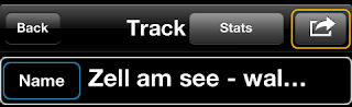
Share track picture via facebook, twitter, email.
You see we have now that unified map and stats view? That was created to share your adventure with friends on facebook, twitter, via email or just saving into camera roll, why not?! Use the action button in the track window:
And pick the facebook option for example:

Here is how our post looks before sending, it is pre-filled from the track name and you can change to whatever you like:

You can also change the album that image will be added to and post visibility between "Only Me", "My Friends" and "Public". Tap on "Post" and it will be published on your facebook timeline.
But facebook is only one from many social options! If you pick "More Sharing Options!":
You'll see the plethora of extra sharing options:

It is disputable if you ever need to assign this image to a contact, but we are leaving it here, who knows...
And how the shared image looks? Just for completeness, here it is:

We hope you'll love to share with friends as we do!
Status: In beta testing.
Change export formats from semi-colon separated to pure comma separated
This one is straight forward and gives you ability to open the lists of tracks or trips in excel without any extra steps to be required.Status: In beta testing.
Single track export in Google Earth format.
In addition to sharing your track map and stats picture via facebook/twitter and many other ways you can now export the single track as a Google Earth archive. Get to the single track view and use a new action button there:

With option to send by email as a Google Earth track:
Here is how the result of this single track export looks in Google Earth:
Status: In beta testing.
Ability to clear the GPS black box or switch it off.
Main driver behind this was to provide more information inside the app what black box is and that it only provide up to 20 last minutes of your travel. Options are added to clear the black box data or switch the black box off altogether. Will provide more images here soon.
Status: In beta testing.
Update to the latest version of Google maps (1.4).
While version 1.5.1 is using Google maps 1.1, version 1.5.2 is now updated to Google maps version 1.4. Google map will still be only available as a live map. Ability to use a map of a choice (Open street map, native Apple's or Google's) will be planned for version 1.5.3.
[Update 17-Aug-2013] It turned out there was a crash bug in version 1.4 and now Google map in the app is updated to version 1.4.2. Google also promises quite a few performance and memory improvements in 1.4.1 and 1.4.2
[Update 17-Aug-2013] It turned out there was a crash bug in version 1.4 and now Google map in the app is updated to version 1.4.2. Google also promises quite a few performance and memory improvements in 1.4.1 and 1.4.2
Status: In beta testing.
Waypoints.
TBD
Status: In beta testing.
Designed for iOS7, still supporting iOS5.1 and iOS6.
TBD
Status: In beta testing.
New main menu.
TBD
Status: In beta testing.
Vibrate instead of or in addition to the sound alert.
Status: In beta testing.
Ability to disable GPS error popups directly from the error message dialog.
Status: In beta testing.
Bug fixes.
1. Fix for built-in iPod player losing the play state if headphones are plugged off while app is not the front
2. Memory and performance optimizations
Can't wait to get those new features?
Okay, there is a limited number of beta apps available. All released betas are stable and don't break your previous data (though there is no 100% warranty with betas). If you use the app actively and don't mind being asked for some feedback from time to time, you can enroll here: http://tflig.ht/10ouUBj. Be sure to tap on this link from your iPhone/iPad, register and add your device to the portal. We'll be sending you a beta download link shortly after that!
No comments:
Post a Comment